HFAM Data Preparation
Tuolumne River, CA
Project: Tuolumne River Watershed
Preparing data inputs is necessary to gain real-time meteorological data

The HFAM Dataprep program is custom software developed by Hydrocomp, Inc to assist in the preparation of real-time meteorological data for use with HFAM. The Dataprep program is customized for use in a particular watershed during the initial setup of the required Dataprep database and watershed map.
Schedule Your HFAM Demo.
HFAM requires the following meteorological data to simulate runoff and snow processes:

TEMPERATURE

PRECIPITATION

EVAPORATION

SOLAR RADIATION

WIND SPEED
Dataprep can be used to prepare HFAM input for any watershed, according to the watershed-specific information provided in the Dataprep database.
Raw data refers to the data observations recorded at the real-time meteorological data collection station as provided by the collection agency.
Final data refers to continuous hourly meteorological time series that represent conditions at the meteorological stations, as required by HFAM.
Standard steps required to prepare HFAM real-time meteorological data input files using Dataprep
- Compile raw data files
- Import raw data
- Check the raw data quality
- Generate final data
- Check the final data quality
- Export the final data
A dataset is a timeseries of data of a specific type (precipitation, temperature, evaporation, solar radiation or wind speed) at a specific station. The final datasets are generated from the raw data and edited (when necessary) to create continuous hourly records at the HFAM stations.
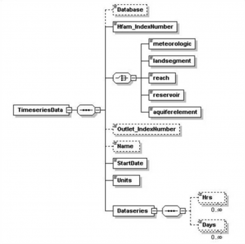
HFAM requires data input files to be in a specific Extensible Markup Language (XML) format. The XML language is a document processing standard for defining the structure of information. The data required in a specific XML file and the structure of these data are defined in a schema.
The schema for HFAM XML daily and hourly timeseries files (timeseries.xsd) is as shown.
Data can be plotted for individual stations, as shown below, or spatially over the land segments defined in HFAM.
HFAM lists each parameter under the hydrologic process that it primarily affects. There is interaction among parameters, in particular for parameters affecting streamflow volumes. This interaction occurs in nature and modeling.
Summary of the Calibration Procedure
To create spatial plots Dataprep uses information provided in an ArcInfo shapefile to generate a watershed map of the HFAM input variables. The shapefile contains the spatial extent of HFAM land segments.


